London Borough of Bexley
W tym artykule poznamy fascynujący świat London Borough of Bexley, który przykuł uwagę zarówno ekspertów, jak i entuzjastów. Od wpływu na współczesne społeczeństwo po korzenie historyczne, London Borough of Bexley był przedmiotem intensywnej debaty i analiz. Na tych stronach będziemy badać różne aspekty London Borough of Bexley, od jego wpływu na kulturę popularną po znaczenie w środowisku akademickim. Mamy nadzieję, że podczas tej podróży zaoferujemy pełny i zróżnicowany obraz London Borough of Bexley, dając naszym czytelnikom głębsze zrozumienie tego fascynującego tematu.
| London Borough of | |||
 Hall Place | |||
| |||
| Państwo | |||
|---|---|---|---|
| Kraj | |||
| Region | |||
| Kod ISO 3166-2 |
GB-BEX | ||
| Burmistrz |
Peter Reader | ||
| Powierzchnia |
60,56 km² | ||
| Populacja (2016) • liczba ludności |
|||
| • gęstość |
4042 os./km² | ||
| Kod pocztowy |
SE2, SE9, SE28, DA1, DA5, DA6, DA7, DA8, DA14, DA15, DA16, DA17, DA18 | ||
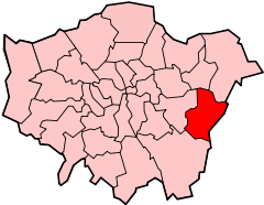
Położenie na mapie Wielkiego Londynu
| |||
| Strona internetowa | |||


London Borough of Bexley – jedna z 32 gmin Wielkiego Londynu położona w jego wschodniej części. Wraz z 19 innymi gminami wchodzi w skład tzw. Londynu Zewnętrznego. Władzę stanowi Rada Gminy Bexley (ang. Bexley Council).
Historia
Gminę utworzono w 1965 roku na podstawie ustawy London Government Act 1963 z obszarów Bexley (ang. Municipal Borough of Bexley) utworzonego w 1894 roku, Erith (ang. Municipal Borough of Erith) utworzonego w 1938 roku, Crayford (ang. Crayford Urban District) utworzonego w 1920 roku oraz z obszaru Chislehurst and Sidcup (ang. Chislehurst and Sidcup Urban District) utworzonego w 1934 roku - oprócz Chislehurst które zostało dołączone do Bromley. Na terenie gminy w Crayford znajdowała się wybudowana w XIX wieku przez Hirama Maxima fabryka broni w której produkowano karabin maszynowy Maxim. Fabryka pod koniec XIX wieku została przejęta przez firmę Vickers i działała aż do 1985 roku kiedy to została zamknięta, zaś pozostałe po fabryce budynki zostały ostatecznie zburzone w 1998 roku.
Geografia
Gmina Bexley ma powierzchnię 60,56 km², od północy graniczy przez Tamizę z Barking and Dagenham i Havering oraz od północnego wschodu także przez Tamizę z dystryktem Thurrock w hrabstwie Essex, od zachodu z Greenwich, od południa z Bromley, zaś od wschodu z dystryktami Sevenoaks oraz Dartford w hrabstwie Kent.
W skład gminy Bexley wchodzą następujące obszary:
|
Gmina dzieli się na 21 okręgów wyborczych które nie pokrywają się dokładnie z podziałem na obszary, zaś mieszczą się w trzech rejonach tzw. borough constituencies - Bexleyheath and Crayford, Erith and Thamesmead i Old Bexley and Sidcup.
|
|
Demografia
W 2011 roku gmina Bexley miała 231 997 mieszkańców.
Podział mieszkańców według grup etnicznych na podstawie spisu powszechnego z 2011 roku:
|
|
Podział mieszkańców według wyznania na podstawie spisu powszechnego z 2011 roku:
- Chrześcijaństwo - 62,1%
- Islam – 2,4%
- Hinduizm – 1,5%
- Judaizm – 0,1%
- Buddyzm – 0,6%
- Sikhizm – 1,8%
- Pozostałe religie – 0,3%
- Bez religii – 24,1%
- Nie podana religia – 7,0%
Podział mieszkańców według miejsca urodzenia na podstawie spisu powszechnego z 2011 roku:
|
|
Transport

Bexley jest jedną z sześciu londyńskich gmin przez którą nie przebiega ani jedna linia metra.
Pasażerskie połączenia kolejowe na terenie Bexley obsługuje przewoźnik Southeastern.
Stacje kolejowe:
- Abbey Wood (na granicy z London Borough of Greenwich)
- Albany Park
- Barnehurst
- Belvedere
- Bexley
- Bexleyheath
- Crayford
- Erith
- Falconwood (na granicy z London Borough of Greenwich)
- Sidcup
- Slade Green
- Welling
Miejsca i muzea


- Crossness Pumping Station
- Hall Place
- Danson House
- Red House
- Sidcup Place
- Geoffrey Whitworth Theatre
- Erith Playhouse
- Edward Alderton Theatre
- Crayford Manor House Astronomical Society
- Crayford Greyhound Track (tory wyścigowe na których rozgrywane są wyścigi chartów)
- Sidcup Golf Club
- Bexleyheath Golf Club
- Barnehurst Golf Course
- Thamesview Golf Centre
Edukacja

- Bird College
- Rose Bruford College
- Adult Education College Bexley
- Bexley College
- Beths Grammar School
- Bexley Grammar School
- Bexleyheath Academy
- Blackfen School for Girls
- Business Academy Bexley
- Chislehurst and Sidcup Grammar School
- Cleeve Park School
- Erith School
- Haberdashers Aske’s Crayford Academy
- Harris Academy Falconwood
- Hurstmere School
- St Catherine's Catholic School for Girls
- St Columba's Catholic Boys' School
- Townley Grammar School for Girls
- Trinity School, Belvedere
- Welling School
- Christ the King: St Mary's Sixth Form College
Znane osoby
W Bexley urodzili się m.in.
- John Paul Jones - producent, aranżer i multiinstrumentalista
- Steve Backley - lekkoatleta
- Kate Bush - piosenkarka
- Boy George – piosenkarz
- Wayne Routledge – piłkarz
- Mike Rann - polityk
- Liam Ridgewell – piłkarz
- Naomi Cavaday - tenisistka
Przypisy
- ↑ Population Estimates for UK, England and Wales, Scotland and Northern Ireland - Office for National Statistics , www.ons.gov.uk (ang.).
- ↑ „ Legislation.gov.uk- London Government Act 1963”
- ↑ „visionofbritain.org.uk - unit history of Bexley”. . .
- ↑ „visionofbritain.org.uk - unit history of Erith”. . .
- ↑ „visionofbritain.org.uk - unit history of Crayford”. . .
- ↑ „visionofbritain.org.uk - unit history of Chislehurst and Sidcup”. . .
- ↑ „gunstribune.com - Hiram Maxim”
- ↑ „crayfordhistory.co.uk - Vickers Ltd of Crayford 1888-1985”
- ↑ „bexley.gov.uk – Election boundaries”. . .
- ↑ „ukpollingreport.co.uk-london”
- ↑ „ons.gov.uk – 2011 Census: KS102EW Age structure, local authorities in England and Wales”
- ↑ „ons.gov.uk – 2011 Census: KS201EW Ethnic group, local authorities in England and Wales”
- ↑ „ons.gov.uk – 2011 Census: KS209EW Religion, local authorities in England and Wales”
- ↑ „ons.gov.uk – 2011 Census: KS204EW Country of birth, local authorities in England and Wales”
- ↑ „crossness.org.uk - Crossness Pumping Station”
- ↑ „hallplace.org.uk - Hall Place”
- ↑ „dansonhouse.org.uk - Danson House”. . .
- ↑ „nationaltrust.org.uk - Red House ”
- ↑ „bexley.gov.uk - Sidcup Place”. . .
- ↑ „thegwt.org.uk - Geoffrey Whitworth Theatre”
- ↑ „playhouse.org.uk - Erith Playhouse”
- ↑ „edwardalderton.org - Edward Alderton Theatre”
- ↑ „cmhas.wikispaces.com - Crayford Manor House Astronomical Society”. . .
- ↑ „crayford.com - Crayford Greyhound Track”
- ↑ „sidcupgolfclub.co.uk - Sidcup Golf Club”
- ↑ „bexleyheath-golf.com - Bexleyheath Golf Club”
- ↑ „mytimeactive.co.uk - Barnehurst Golf Course”. . .
- ↑ „tvgc.co.uk - Thamesview Golf Centre”
- ↑ „birdcollege.co.uk - Bird College”
- ↑ „bruford.ac.uk - Rose Bruford College”
- ↑ „adultedbexley.co.uk - Adult Education College Bexley”. . .
- ↑ „bexley.ac.uk - Bexley College”. . .
- ↑ „beths.bexley.sch.uk - Beths Grammar School”. . .
- ↑ „bexleygs.co.uk - Bexley Grammar School”
- ↑ „bexleyheathacademy.org - Bexleyheath Academy”
- ↑ „blackfenschoolforgirls.co.uk - Blackfen School for Girls”
- ↑ „thebusinessacademy.org - Business Academy Bexley”
- ↑ „csgrammar.com - Chislehurst and Sidcup Grammar School”
- ↑ „cleevepark.org - Cleeve Park School”. . .
- ↑ „erith.kent.sch.uk - Erith School”. . .
- ↑ „haaf.org.uk - Haberdashers Aske’s Crayford Academy”. . .
- ↑ „harrisfalconwood.org.uk - Harris Academy Falconwood”
- ↑ „hurstmere.org.uk - Hurstmere School”
- ↑ „stccg.co.uk - St Catherine's Catholic School for Girls”
- ↑ „st-columbas.bexley.sch.uk - St Columba's Catholic Boys' School”
- ↑ „townleygrammar.org.uk - Townley Grammar School for Girls”
- ↑ „trinity.bexley.sch.uk - Trinity School, Belvedere”
- ↑ „welling.bexley.sch.uk - Welling School”
- ↑ „ctksfc.ac.uk - Christ the King: St Mary's Sixth Form College”
