Yangon City Hall
| Designations | |
|---|---|
.jpg)
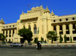
Yangon City Hall (Burmese: ရန်ကုန်မြို့တော်ခန်းမ; YCH) is the city hall of Yangon, the largest city of Myanmar, and the seat of the city's administrative body, Yangon City Development Committee (YCDC). The building is considered a fine example of syncretic Burmese architecture, featuring traditional tiered roofs called pyatthat, and was designed by Burmese architect U Tin, who also designed Central Railway Station.[1] Construction began in 1926 and ended in 1936.[2] The city hall occupies the former site of the Ripon Hall.[2]
The city hall has been the focal point of several major political demonstrations, including a 1964 People's Peace Committee rally supported by Thakin Kodaw Hmaing, which attracted 200,000 people and was subsequently clamped down by Ne Win's military junta.[3] and the site of several bombings, including one in 2000, 2008, and 2009.[4][5]
Centrally located in downtown Yangon, it is next to several important landmarks such as Sule Pagoda, Maha Bandula Park, High Court, and the Main Post Office.
The building is listed on the Yangon City Heritage List.
Gallery
-
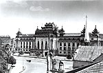 Yangon City Hall in 1945, after World War II
 -
 Yangon City Hall in 2008
 -
 Yangon City Hall seen from Maha Bandula Park
 -
 Yangon City Hall


References
- ^ Falconer, John; et al. (2001). Burmese Design & Architecture. Hong Kong: Periplus. ISBN 962-593-882-6.
- ^ a b Tin Mg Oo (2003). Aspects of Myanmar Culture (PDF). Yangon: Zun Pwint Publishing House. pp. 56–58. Retrieved 2010-09-19.
- ^ Historical dictionary of Burma (Myanmar) By Donald M. Seekins, p. 356
- ^ "Yangon blast wounds 4 as protest anniversary looms".
- ^ "Bomb Blasts in Burma—A Chronology". Archived from the original on 2012-02-29. Retrieved 2010-08-03.