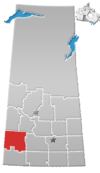
Eston, Saskatchewan
Eston, Saskatchewan | |
|---|---|
Town | |
| Coordinates: 51°05′25″N 108°27′03″W / 51.0904°N 108.4509°W | |
| Country | Canada |
| Province | Saskatchewan |
| Census division | 12 |
| Rural Municipality | Snipe Lake |
| Government | |
| • Governing body | Eston Town Council |
| Area | |
• Total | 2.72 km2 (1.05 sq mi) |
| Population (2016[1]) | |
• Total | 1,061 |
| • Density | 390.3/km2 (1,011/sq mi) |
| Time zone | CST |
| Area code | 306 |
| Highways | Highway 30 Highway 44 |
| Railways | Canadian National Railway |
| Website | Official Website - Town of Eston |
| [2][3][4][5] | |
Eston is a town in the Rural Municipality of Snipe Lake No. 259, Saskatchewan, Canada. The population was 1,061 at the 2016 Census. The town is located at the junction of Highway 30 and Highway 44, approximately 70 kilometres (43 mi) south-east of Kindersley. Eston Riverside Regional Park is 21 kilometres (13 mi) south of town on the north bank of the South Saskatchewan River.
Demographics
In the 2021 Census of Population conducted by Statistics Canada, Eston had a population of 972 living in 426 of its 492 total private dwellings, a change of -8.4% from its 2016 population of 1,061. With a land area of 2.65 km2 (1.02 sq mi), it had a population density of 366.8/km2 (950.0/sq mi) in 2021.[6]
Climate
Eston experiences a semi-arid climate (Köppen climate classification BSk) with long, cold, dry winters and short but very warm summers. Precipitation is very low, with an annual average of 297mm, and is heavily concentrated in the warmer months.
The town experienced "severe damage" to buildings as a result of plough winds during a severe thunderstorm on July 14, 2019.[7]
| Climate data for Eston | |||||||||||||
|---|---|---|---|---|---|---|---|---|---|---|---|---|---|
| Month | Jan | Feb | Mar | Apr | May | Jun | Jul | Aug | Sep | Oct | Nov | Dec | Year |
| Record high °C (°F) | 9.5 (49.1) |
13.5 (56.3) |
20.5 (68.9) |
32.5 (90.5) |
36.1 (97.0) |
39.5 (103.1) |
39 (102) |
38.9 (102.0) |
36.7 (98.1) |
32.2 (90.0) |
21.7 (71.1) |
11.7 (53.1) |
39.5 (103.1) |
| Mean daily maximum °C (°F) | −9.5 (14.9) |
−6.5 (20.3) |
1.5 (34.7) |
11.8 (53.2) |
19.3 (66.7) |
23.5 (74.3) |
25.6 (78.1) |
25 (77) |
18.7 (65.7) |
11.7 (53.1) |
−0.5 (31.1) |
−7.7 (18.1) |
9.4 (48.9) |
| Daily mean °C (°F) | −14.3 (6.3) |
−11.5 (11.3) |
−4 (25) |
4.8 (40.6) |
11.7 (53.1) |
16.2 (61.2) |
18.1 (64.6) |
17.4 (63.3) |
11.4 (52.5) |
4.9 (40.8) |
−5.6 (21.9) |
−12.5 (9.5) |
3 (37) |
| Mean daily minimum °C (°F) | −19.1 (−2.4) |
−16.5 (2.3) |
−9.5 (14.9) |
−2.2 (28.0) |
4 (39) |
8.8 (47.8) |
10.5 (50.9) |
9.7 (49.5) |
4 (39) |
−2 (28) |
−10.7 (12.7) |
−17.3 (0.9) |
−3.4 (25.9) |
| Record low °C (°F) | −47.8 (−54.0) |
−40.5 (−40.9) |
−40.6 (−41.1) |
−28.6 (−19.5) |
−11.1 (12.0) |
−4.4 (24.1) |
−1.1 (30.0) |
−2.8 (27.0) |
−10.6 (12.9) |
−26 (−15) |
−35 (−31) |
−43.9 (−47.0) |
−47.8 (−54.0) |
| Average precipitation mm (inches) | 13 (0.5) |
9.5 (0.37) |
14.8 (0.58) |
19.5 (0.77) |
37.8 (1.49) |
53.2 (2.09) |
53.1 (2.09) |
39.3 (1.55) |
20.3 (0.80) |
11 (0.4) |
11.1 (0.44) |
14.6 (0.57) |
297.2 (11.70) |
| Source: Environment Canada[8] | |||||||||||||
Notable people
- Michael Helm, author
- Robert Steadward, founder of the International Paralympic Committee[9][10]
See also
References
- ^ "Census Profile". 2016 Census. Statistics Canada.
- ^ National Archives, Archivia Net, Post Offices and Postmasters, archived from the original on 6 October 2006
- ^ Government of Saskatchewan, MRD Home, Municipal Directory System, archived from the original on 21 November 2008
- ^ Canadian Textiles Institute. (2005), CTI Determine your provincial constituency, archived from the original on 11 September 2007
- ^ Commissioner of Canada Elections, Chief Electoral Officer of Canada (2005), Elections Canada On-line, archived from the original on 21 April 2007
- ^ "Population and dwelling counts: Canada, provinces and territories, census divisions and census subdivisions (municipalities), Saskatchewan". Statistics Canada. 9 February 2022. Retrieved 1 April 2022.
- ^ "Eston suffers extensive damage in overnight storm". CTV News Saskatoon. Retrieved 15 July 2019.
- ^ Environment Canada Canadian Climate Normals 1971–2000, accessed 27 July 2010
- ^ "Robert D. Steadward OC, PhD, LLD (Hon)". Lieutenant Governor of Alberta. 2010. Retrieved 19 February 2020.
- ^ "Dr. Robert Steadward". Canada's Sports Hall of Fame. 2007. Retrieved 19 February 2020.

